Catastrophic Flooding in Central Texas Over July 4 Weekend
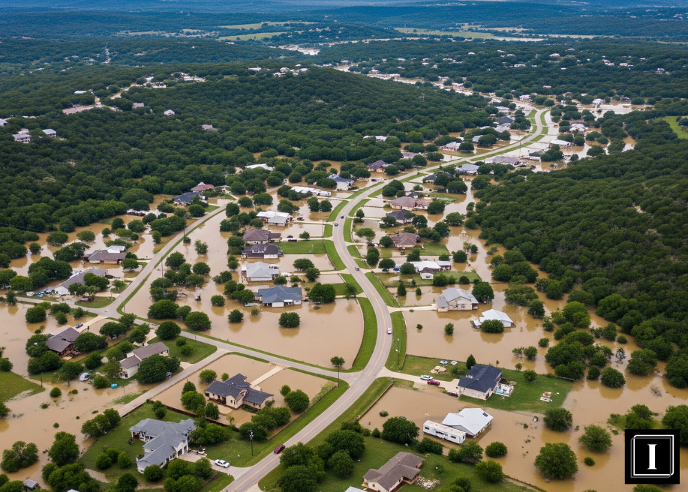
A deadly convergence of storms swept across Central Texas over the Fourth of July weekend, causing catastrophic flooding that led to the deaths of at least 70 people. The devastation was most severe in Kerrville, located in the Texas Hill Country, which is notorious for flash flooding. Rainfall rates reached up to 4 inches per hour, overwhelming the region’s rivers and streams and triggering flash floods that caught many off guard.
Central Texas Flooding Hits Hill Country Hardest
The Central Texas flooding was intensified by a powerful storm system that lingered over the Hill Country region between San Antonio and Austin. Despite Kerrville receiving over 11 inches of rain in just three days, nearby towns experienced even greater deluges—nearly double the rainfall totals—according to the National Weather Service (NWS).
One of the most tragic incidents occurred at Camp Mystic, a girls’ summer camp near Kerrville. Here, the Guadalupe River rose dramatically, surging from under two feet to over 34 feet in just over an hour on July 4. This sudden rise was due to a combination of sustained rainfall and rapidly overwhelmed waterways.
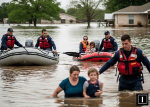
Kerr County Sheriff Larry Leitha confirmed that among the 70 lives lost, 38 were adults and 21 were children—many of whom were swept away before rescue crews could respond.
Rainfall Totals and Storm Impact
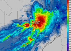
On Independence Day, rain was falling at staggering rates—3 to 4 inches per hour—with some areas receiving as much as 7 inches in three hours. To put this into perspective, 7 inches of rain equals 122 million gallons of water per square mile. Over a 7-square-mile area, that’s enough to fill AT&T Stadium, home to the Dallas Cowboys.
While Kerrville suffered extreme damage, even heavier rainfall occurred west of the city, further straining emergency response efforts across multiple counties. First responders across Central Texas were pushed to their limits as roads washed out and riverbanks eroded at dangerous speeds.
Why the Hill Country Flooded So Fast
The Texas Hill Country, often referred to as “Flash Flood Alley,” is prone to rapid and extreme flooding due to its unique topography. Warm, moisture-rich air from the Gulf of America (formerly known as the Gulf of Mexico) frequently moves inland, interacting with the steep terrain. When storm systems stall over the region, they release torrents of rain in a short span.
Alan Gerard, CEO of Balanced Weather, explained that the Gulf’s unusually warm temperatures helped fuel the storm system. “Thunderstorm activity became highly concentrated due to the atmospheric setup,” he said. “Unfortunately, it all focused in exactly the wrong place on July 4.”
Ongoing Risks and Community Response
As communities begin to assess the damage, search-and-rescue missions continue, with many still unaccounted for. Emergency shelters have been set up across affected counties, and authorities are urging residents to stay clear of flood-prone areas due to ongoing risks of flash flooding.
Federal and state agencies are mobilizing aid, while meteorologists warn that additional rain could worsen the crisis in the coming days.
Read more on environmental risk and resilience in IMPAAKT, your top business magazine for sustainability insights and crisis response.